

Middle Rockies - Blue Mountains
© Florian Schulz Middle Rockies - Blue Mountains Featured Image
Description & Physiography
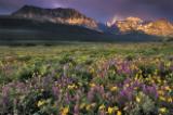
The Middle Rockies – Blue Mountains Ecoregion represents a large mass of mountains and intermontane valleys covering major portions of Oregon, Idaho, and Montana, and a small part of Washington. While the ecoregion is topographically diverse, it can generally be characterized as rugged.
Abrupt elevation changes of 3,000 to 4,000 feet from valley floors to mountain summits are not uncommon. The higher elevations were strongly glaciated, resulting in sharp ridges and cirques at the heads of large U-shaped valleys. The major drainages are deeply incised, resulting in steep breaklands. One extreme, the deepest part of Hells Canyon on the Snake River drops some 8,000 feet in elevation in the span of just four miles. The lowest elevation in the ecoregion is 790 feet, where the Snake River flows out of Hells Canyon south of Lewiston, Idaho, while the highest occurs on Borah Peak at 12,662 feet, in the Lost River Range of central Idaho.
Plants & Animals
The dominant vegetation of the ecoregion is coniferous forest, however the elevational diversity contributes to a variety of ecological systems ranging from sagebrush-grasslands to subalpine meadows, alkaline fens to salt-desert scrub. There are over 500 different plant associations found within the ecoregion. The ecoregion contains at least 109,000 miles of streams and rivers and spans two of the major hydrologic divides of North America: the Continental Divide along the crest of the Rocky Mountains, dividing the Pacific and Atlantic basins, and the divide between the Pacific and the Great Basin, along the crest of the Blue Mountains in Oregon. Native fish species found in the ecoregion include sockeye salmon, chinook salmon, bull trout, white sturgeon, river lamprey, Yellowstone cutthroat trout and Montana arctic grayling.
Humans & History
Most of the ecoregion is public land managed for various purposes by federal and state agencies. Of these public agencies, the U.S. Forest Service is the largest manager, with 52 percent of the land, while the Bureau of Land Management is a distant second at 9 percent. Thirty-four percent of the ecoregion is private land. The only large industrial land owners are timber companies, Boise Cascade and Plum Creek Timber Company.
Learn More
Go to the Map

Use the interactive map to zoom smoothly from a national view to state and local perspectives anywhere across the country.
Go Straight to Your State
Learn about conservation and open space in your state.

